
Exploring a Digital Atlas of Maps and Imagery on Soar.Earth
In this post I want to share with you a relatively new platform, called Soar.Earth (launched in 2018) that I just found out about a couple months ago. The Soar team (who are readers of my blog) invited me to become one of their power-users to test and review their Soar.Earth geospatial platform. That being said, this is a sponsored post (my first) by Soar.Earth that I am reviewing and providing a short tutorial for in this post. Though, opinions expressed in this post are solely my own.
So without further ado, what is Soar.Earth? It is a digital atlas of all the world’s maps and imagery, such as aerial and satellite imagery, remotely sensed data, drone/UAV imagery, and other cartographic products (e.g. scanned paper maps). The contents of this digital atlas are primarily user generated, meaning anyone can contribute and share their maps and imagery with the world. For satellite imagery, currently there are Sentinel Hub, Landsat/NASA and SkyMap50 with more providers being added in the near future. You can explore, download and share all of these raster data on the platform.
When I started exploring what Soar.Earth had to offer one of the things that got my attention right away were the captivating maps and images uploaded by users from all over the world. As part of my job, I probably spend about half my time doing cartographic design and production; and as a cartography nerd I love seeing all the beautiful maps and images that others have produced and shared - they are very inspiring to me. Some of these stunning images remind me of the NASA/USGS’s Earth as Art series, which if you enjoy them as much as I do then you’d love exploring the contents on Soar.Earth. See some examples below.

User generated map images on Soar.Earth
As beautiful as some of these maps and drone imagery are, I think it’s important to note that the intent is not for all of these contents to become “stock photos/images” on the platform. If anything, the intent is to eventually have all the maps and drone imagery become useable mapping data which is where the real value of the content lies.
Signing Up for a Free Soar Account
If you want to just check it out, go to Soar.Earth. You can start exploring all the contents on the platform right away without needing to register. However, to fully experience the application and its capabilities, such as satellite searches, uploading images, and being able to sell your images then you’ll need to sign up for a free account. To preview Soar’s capabilities, see their promo video on YouTube.
The process is quick and easy, only requiring your name, email, and a password – done in 3 quick, easy steps shown below. Once you sign into your account, use the dashboard to fill in your profile information. The dashboard is where you can link to your other social media accounts so it shows up in your user profile when someone clicks on a map or image you’ve uploaded.

If you are interested in having your own private digital atlas, there is the paid version of the platform, called Soar+ - with this version you get your own custom sub-domain URL (e.g. opengislab.soar.earth) and choose how you want to share your maps and images. There are two plans, a Soar+ Professional and an Enterprise version - see the pricing plans for more information.
After you sign up for a free account, continue following along to get started with using the Soar.Earth platform. There is a short interactive guide at start up to give you a quick tour of the application as well.
The User Interface
Here is a quick run down of the user interface, showing where the panels and tools are.

Viewing Map Images
Option 1: Maps Tab of Curated Images
There are two ways you can start exploring maps. Option 1 is using the Maps tab. If you click on the Maps tab it will expand to show thumbnails of map images uploaded and shared by users. These are curated by the Soar team to highlight some of the user generated contents you can view. Hovering on one of the thumbnail images will display its title; and if you click on it, the map display will automatically zoom to it.
For example, one of my favorite is the image, titled “Eye of the Sahara – Richat Structure” - if you click on it the map display will zoomed to its location. You can then interact with the map image, by changing the basemap (lower right corner) and image transparency (slider on info panel).
An information panel with the user’s profile (person who uploaded and shared the image) and a description of the map image will be displayed along with map image. If the user has filled in their user profile information in the Soar account dashboard then links to their social media will be displayed as well. Note, you cannot download these map images, however, you can like and share this map image with others via Twitter, Facebook, LinkedIn.
If you click on the Back arrow in the information panel it will show if there are other map images available within the vicinity of the bounding polygon extent. Using the “Eye of the Sahara” as an example: if you hover your mouse in the polygon you can see there are two images in this area. Another user has a different map image of the same Richat Structure (right thumbnail). It’s interesting that these two map images are of the same geography/structure but they offer different perspectives for the viewer. For me, I prefer to view the Richat Structure in the yellow-orange-red color scheme, reminiscent of a burning sun perhaps that I think perfectly captures the sense of the place - a hot, dry, desert. This is not to say one is better than the other - it’s more about what the map image conveys to the viewer (me). After all, a map should be able to effectively communicate a sense of the place that it is mapping. Which map image do you prefer? What feelings do these map images evoke for you? Maybe you can create your own map and share with everyone a sense of your “place.”

Option 2: Interacting with the Map Display
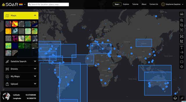
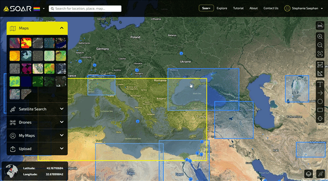
Option 2 for exploring maps is just by navigating to an area of interest (AOI) on the map display panel and clicking on a polygon showing the extent of a map image(s) or and a numbered dot/circle that shows the number of maps available in a particular area. See the corresponding animated gif below as an example.
If you haven’t noticed already, the entire Soar.Earth application is very responsive/dynamic - the polygon extents change as you zoom in/out of the maps and the clustering of points are also dynamic. Hovering your mouse over an area will highlight the particular polygon and show maps within that extent. Clicking on a clustered dot will zoom into the maps’ local extents. See it in action below.
I don’t know about you, but I could spend all day just going around the world exploring all the beautiful maps people are creating and sharing. My only wish is that I could see these places in person - maybe someday, but for now I can live vicariously through Soar.Earth :)
Viewing Drone Imagery
Viewing drone imagery follows the process as viewing map images. When you click on the Drones tab, only the drone imagery contents will show up on the map display. Under the Drones tab, there are some curated drone imagery as well. Note the different colors for dynamic point clustering of the drone imagery. The color coded scheme indicates the count (e.g. a single image, a few, or many images) of drones imagery within an area.
Explore the drone imagery by clicking on some of the curated thumbnails under the Drones tab or see the section on Searching the catalog below.

Notice that some of the drone imagery are free to download and some are for purchase. If you are a drone professional or even a hobbyist, you could share your imagery or even make some money for your hard work. If you decide to sell your imagery - keep in mind there is a percentage ratio on the sale price (contact Soar for more information). As for map images for purchase - I haven’t noticed any of those but it doesn’t mean there aren’t any for sale (maybe just the ones I viewed weren’t for sale and only can be viewed and shared).

Drone imagery for sale (left) and free download (right)
Uploading Maps and Drone Imagery
Uploading a map or drone imagery is straight forward. Clicking the Upload tab will bring up two options for uploading a Single Drone Image or Aerials & Satellite Images, Mosaiced Drone Images or Customized Maps.
All you need to do is select which option you want for uploading and follow the instructions. Note that any map image you upload must be your own work or one that you have the rights to upload and share with the public (terms of use/service). Although it isn’t specified, the upload file size limit is ~1GB. If you try to upload a file size that is larger than that, you’ll get a message that it’s too big. Being able to upload a file up to 1GB is unheard of for a free application in my opinion. I was able to upload a map image that was ~400MB quickly and with no issues. To note, I didn’t notice file size having any effect on map display - Soar as I understand uses their own tiling system that seems to work pretty well.
I don’t have any drone images to upload, but here is an example of a geotiff of Diamond Head I created from one of my previous tutorials on 3D DEM map image. The application will pick up the metadata in the geotiff and zoom to the location of where your map is located. All you have to do then is just fill in some information about your map image and upload it. Once your file finishes uploading, you’ll get a notice to wait up to 24hrs for your image to be approved. Once approved your maps will show up under the My Maps tab.


Here is a look at the Diamond Head image I uploaded. After I was notified by email that it was approved, I went to My Maps tab and click on the image I want to view.

Searching for Maps and Drone Imagery
The Maps and Drones tabs only show a set of curated maps and drone imagery, but there are much more content on the platform. Currently there are ~800 maps and ~6000 drone imagery, with many more being added daily.
To explore or search for more maps and drone imagery, go to the Explore menu (top right). The Explore page allows you to search Soar’s content catalog.

Satellite Searches
The Satellite Search tab offers the ability to search for satellite images from Sentinel (free), Landsat/NASA (free) and SKyMap50 Archive. You can also search for and purchase high resolution images at 50cm using the SkyMap50 service.
Satellite searching again is really easy, just click on the satellite you want to search by and follow the guided instructions. One thing that’s really cool is the satellite path tracking in near real time - hover your mouse over the satellite icon (bottom right) and check the satellite path(s) you want to see.

Sentinel Hub Example
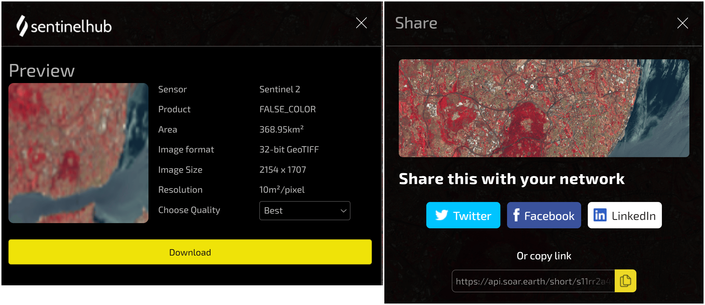
Here is an example, searching the Sentinel Hub. Again, it’s really easy - in a few quick steps (see below) I can search and find Sentinel imagery.
First navigate to your AOI (e.g. Lisbon area) in the map display area
Click Sentinel Hub under the Satellite Search tab
In the Sentinel panel, click the Draw AOI button. Then on the map draw a square/box of your AOI
Wait for search results then select your product (e.g. False color, geology, NDVI, etc.) and date. From there, download or share.
The results of my example search using Lisbon as my AOI are shown below. In the results panel, I can select by product (layer) and date to see availability. Here, my example is showing a False Color layer from July 16, 2021 (the latest from Sentinel at the time of this writing). I can then download and share this image with others. Now that’s easy and pretty cool!

Tools Toolbar
Built into the application are some useful tools that you can use to markup or annotate the map display. You can then export a link (#9) to share with another user. The annotation markups are saved locally and not on the Soar server so when you close out of your current session they disappear - although if you save the exported URL link you can still see the annotation markups after signing in. This makes it feel a little clunky - but I'm told that it will be replaced or enhanced by "Reddit for Maps” tools soon (see section on future development below).
KML Import: Allows importing a KML file. You can use the extent of your KML file to help you draw an AOI when doing satellite searches.
Area Measurement: Draw a square and calculates the area in km2. Not free form polygon draw. You need to select the square then edit vertices to change shape.
Ruler: Measures a line distance (length) in km
Text: Field: Add text to the map display
Arrow: Add an arrow to the map display
Circle: Add a circle to the map display
Square: Add a square to the map display
Latitude/Longitude: Add lat and long coordinates to the map display. The yellow corner (bottom right) is the location of the lat/long coordinates given
Export Share Link: Only displayed after a tool has been used, otherwise not shown. Copy URL link to clipboard and share with other users (must have a Soar account).
Delete (global): Only displayed after a tool has been used, otherwise not shown. This is a global function and will DELETE ALL GRAPHICAL ELEMENTS on the map display. To delete an individual element, select it on the map display then use the delete button for that particular graphic element.

Here is a view of the annotation markup as seen on a different browser using the URL copied from the export shared link button. The annotation markups are the same but the basemap setting went back to the default.

Future Developments and Overall Thoughts
I’ve spent a bit of time reviewing and exploring Soar.Earth and I’m very impressed with what I’m seeing so far. The platform is fairly intuitive and easy to use. But aside from that, I think it is really the user created or community driven contents on the platform that makes it stand out from other geospatial platforms I’ve seen. Even though most of the contents are user generated, there is a Soar administrative group and vetting process in place to ensure that what users upload at least meet some quality standards. I think this is important to point out, as one of Soar’s goal is to eventually have all the maps and drone imagery become mapping data.
The concept of this platform is simply democratizing geospatial data, that is making maps and imagery accessible to everyone (anyone can use the platform and upload and share their maps). I love that aspect of it, as well as the “social” and community engagement among users (e.g. ability to like a map, follow a user (soon to be implemented), and share via Twitter, Facebook, etc.). I think this is one of the things that make Soar.Earth a unique geospatial platform.
I already enjoy using this platform, but what I’m really excited about are some upcoming new features that are in beta or coming soon. I’m looking forward to these features and maybe writing an update review for them when they come out.
“Reddit for Maps” (not official name) coming in Q3 2021, which is exactly what it sounds like, Reddit but for Maps. A place-based or map-based platform for community engagement and commenting. I’ve seen a demonstration of this and it’s a really nice public commenting system. This will be an enhancement of some of the current annotation/markup tools.
Rectification/Georeferencing tool coming in late Q3 2021 as well. This tool will allow users to upload and georeference or rectify a map or image right inside the application. This comes in handy if you have a tiff, jpg, or png (formats that will be accepted) that doesn’t have a coordinate reference system already. I would imagine this tool to be very useful for lots of people. I’m already thinking I could use it to georeference all the historical, cultural paper maps we have and make use of in our geodesign process.
GeoStore slated for Q1 2022. This will be a place for users to buy and sell maps, imagery, other custom cartographic products and services, such as 3rd party provided geo-analytics. The drone imagery for sale that are on the platform now will be transferred over to this new GeoStore system as well.
That’s it for this post. I hope you find it useful. If you’d like to learn more or see some video tutorials, check out Soar’s official YouTube channel and their Medium page.
I hope you get to try out Soar. Earth and maybe share your maps and imagery. Share your Soar imagery link in the comments section - I’d love to see your maps.
As always, thank you so much for reading. Until next time :)