Got GeoJSON Error? - Tip on Adding GeoJSON via URL in QGIS

This post an addendum to an older, previous post on Adding and Viewing GeoJSON in QGIS and ArcGIS. This comes from a tip I provided a blog reader who was having trouble adding geojson file via URL in QGIS from Fulcrum. If you are having trouble connecting to geojson data via URL, give this tip a try and see if it works.

QGIS 3.10 is the version I’m using. Below is the link to an example geojson file I’m testing in this post.

Example geojson URL: https://www.nanaimo.ca/crimereporting/api/incidents.geojson

Errors when trying to Add geojson

Brief summary on how to add Geojson:

Go to Layer Menu >> Layer >> Add Layer >> Add Vector Layer

In the Data Source Manager window:

  1. Click the option Protocol: HTTP(S), cloud, etc.

  2. Select encoding type: UTF-8 or System (mine defaulted to UTF-8)

  3. Type: You can use either HTTP/HTTPS/FTP, Geojson, or Geojson - Newline delimited

  4. Type in URL and click Add

Fig0001.jpg

It should add the geojson file to my map BUT instead I get this error: Invalid Data Source. Clicking Yes to try File source type fails also.

Fig0002.png

When looking in the error log messages (click the message button in the bottom right if you don’t see the log messages panel) - I see the errors that the geojson url is invalid data source and that there is a SSL certificate problem as seen in the images below

Fig004A.png

My understanding from doing some research is that this occurs in QGIS because of outdated openssl library. To work around this you could try use changing the link to just use http instead of https — sometimes this works but in my case it did not. Below are the work around options to try:

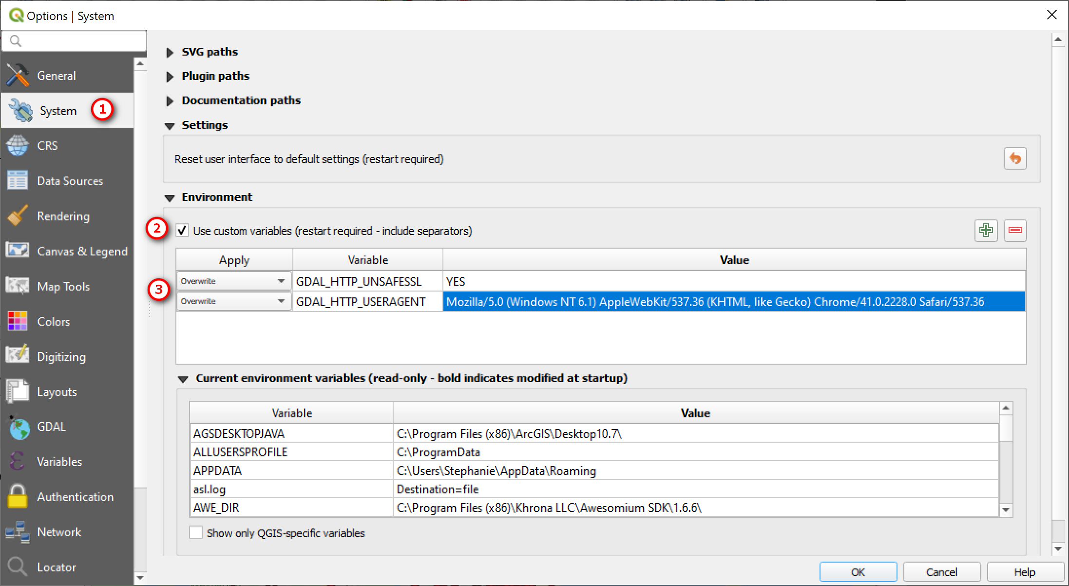
Change the environmental setting variables in QGIS

Go to Setting Menu >> Options

In the Options window:

  1. Go System

  2. Expand Environment: check the box to Use custom vairables

  3. Then add the following Variables

Variable: GDAL_HTTP_USERAGENT

Variable Value: Mozilla/5.0 (Windows NT 6.1) AppleWebKit/537.36 (KHTML, like Gecko) Chrome/41.0.2228.0 Safari/537.36

Variable: GDAL_HTTP_UNSAFESSL

Variable Value: YES

Restart QGIS and them try to add the GeoJSON file link again.

Fig0005.png

If the above work around doesn’t work you may want to also add the variables to your OS system properties and see if that works.

So now if I reopen QGIS and add in the geojson URL it should work - this is what you should see if you use the example URL link given above.

Fig0010.png

That’s it for this post. I hope this helps for those having trouble adding geojson files via URL. If you have any questions, comments, or suggestions for future blog posts please let me know.

Thanks for reading. Until next time.

Adding and Viewing GeoJSON in QGIS and ArcGIS

Sorry I’m been on hiatus for a few months. But I’m back with a short post on adding and viewing geojson data in QGIS and ArcGIS Desktop. I was inspired to write this post after seeing a recent map in the New York Times that showed all the buildings in the U.S. Check out their interactive map of every building in the United States if you haven’t seen it already. It showcases the use of Microsoft (Bing) building footprints database for all 50 States. The NYT maps showed some interesting patterns of the urban landscapes in America which I’ve taken snapshots of and are shown here.

NYTMap.png

The Bing building footprints are open source and can be downloaded for use in geojson format - which is what this post is about. Once you download the geojson file, how do you view it? Anyway, I was interested in seeing what the building footprints look like for Hawaii as well as wanting to do a quick comparison of the Microsoft/Bing buildings outlines to the one that the City and County of Honolulu has and the OSM buildings extract. QGIS can natively open geojson file but it doesn’t always consistently work – at least for me, and I’m not sure why it works sometimes or doesn’t. You can try doing one of the following options below to add geojson to QGIS for viewing.

Adding a local geojson data in QGIS

If you have a geojson file on your local hard drive or network and want to view/use it in QGIS, you can just drag and drop it from the Browser Panel into the Layers Panel or just double click on the file will add it to the Layers Panel. If trying to add the original *.geojson file crashes the you can try changing the files extension to either *.json or even as *.geojson.txt. I’ve tried all 3 different file extensions and they all seem to work.

Fig0005.png

Adding a geojson data via URL

SEE ADDENDUM POST (02/01/2020): GOT GEOJSON ERROR WHEN ADDING VIA URL

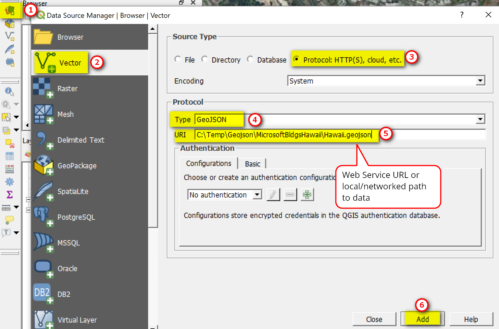
You can also add geojson fiel via a web service URL or a local networked drive. Just click the Open Data Source Manager button >> Vector Data >> Protocol HTTP(S), cloud, etc. >> Select GeoJSON type >> URI path >> Add.

Fig0006.png

Adding and viewing geojson data in ArcGIS Desktop and ArcGIS Pro

ArcGIS desktop and Pro can also read geojson files but it’ll cost you a pretty penny ($$$) because you need the data interoperability extension. In this case I would stick with QGIS, but I listed the steps for ArcGIS below for your information.

Note: Viewing geojson file in ArcGIS Desktop and ArcGIS Pro requires a Data Interoperability Extension, and it needs to be activated or turned on first.

I have Data Interoperability extension so was able to just add the geojson file in ArcMap. I guess ArcGIS desktop with the Data Interoperability extension turned on it somehow automatically imported the geojson file in ArcMap for me. I tried to see if I can also view the geojson file in ArcGIS Pro but the file format was not recognized. With ArcGIS Pro you have to convert geojson file first to json or something else that ArcGIS Pro can use. ArcGIS Online will read geojson though. I’m using the most current version of ArcGIS Desktop 10.6.1 and ArcGIS Pro 2.2.3.

To add and view geojson file in ArcMap, just use the Add Data button as you would to add a shapefile or geodatabase feature class - like the example below.

ArcMapAddGeojson.png

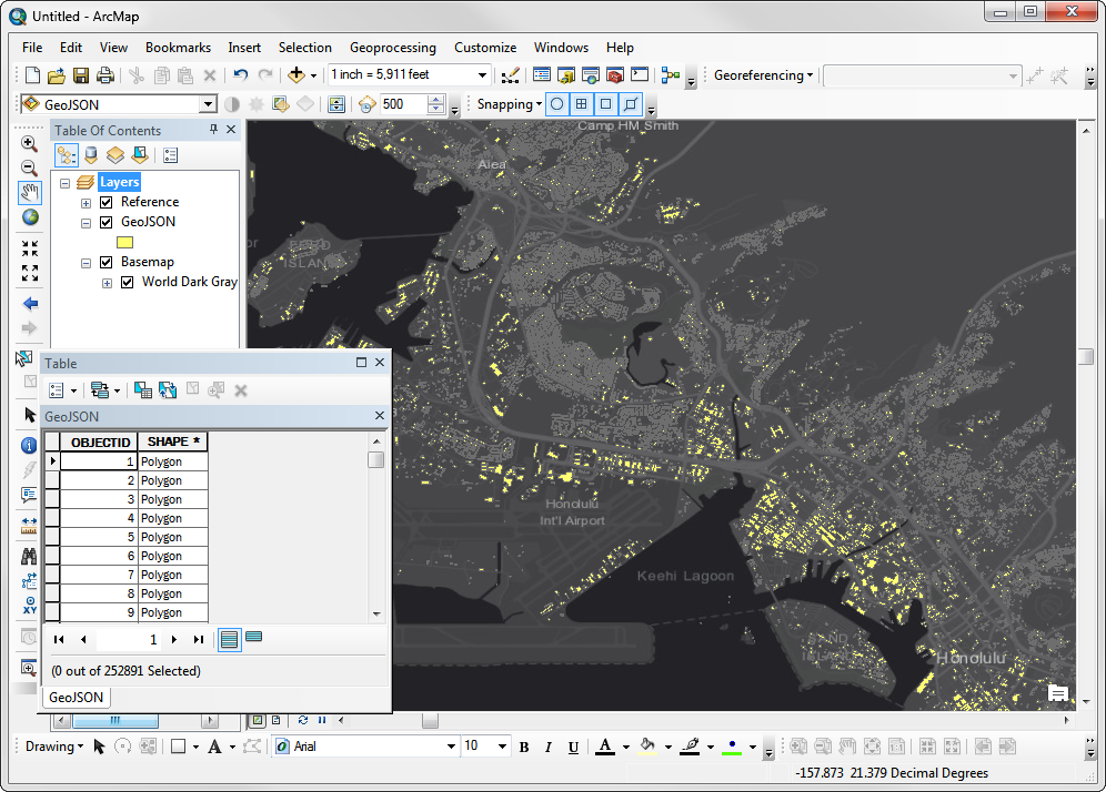
Below is the building geojson file as viewed in ArcMap.

ArcMapGeojson.png

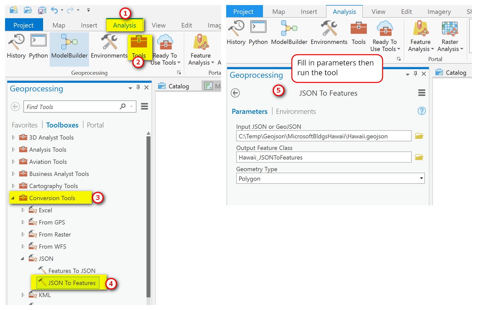
As I said earlier, ArcGIS Pro doesn’t recognize geojson. You’ll need to convert the file to a shapefile or feature class first below you can view it. You can follow the steps for converting JSON to Features tools in AG Pro.

Fig0011.png

Once you convert the geojson file then you can use it in Pro. This is how Bing’s building footprints look like in Pro.

Fig0012.png

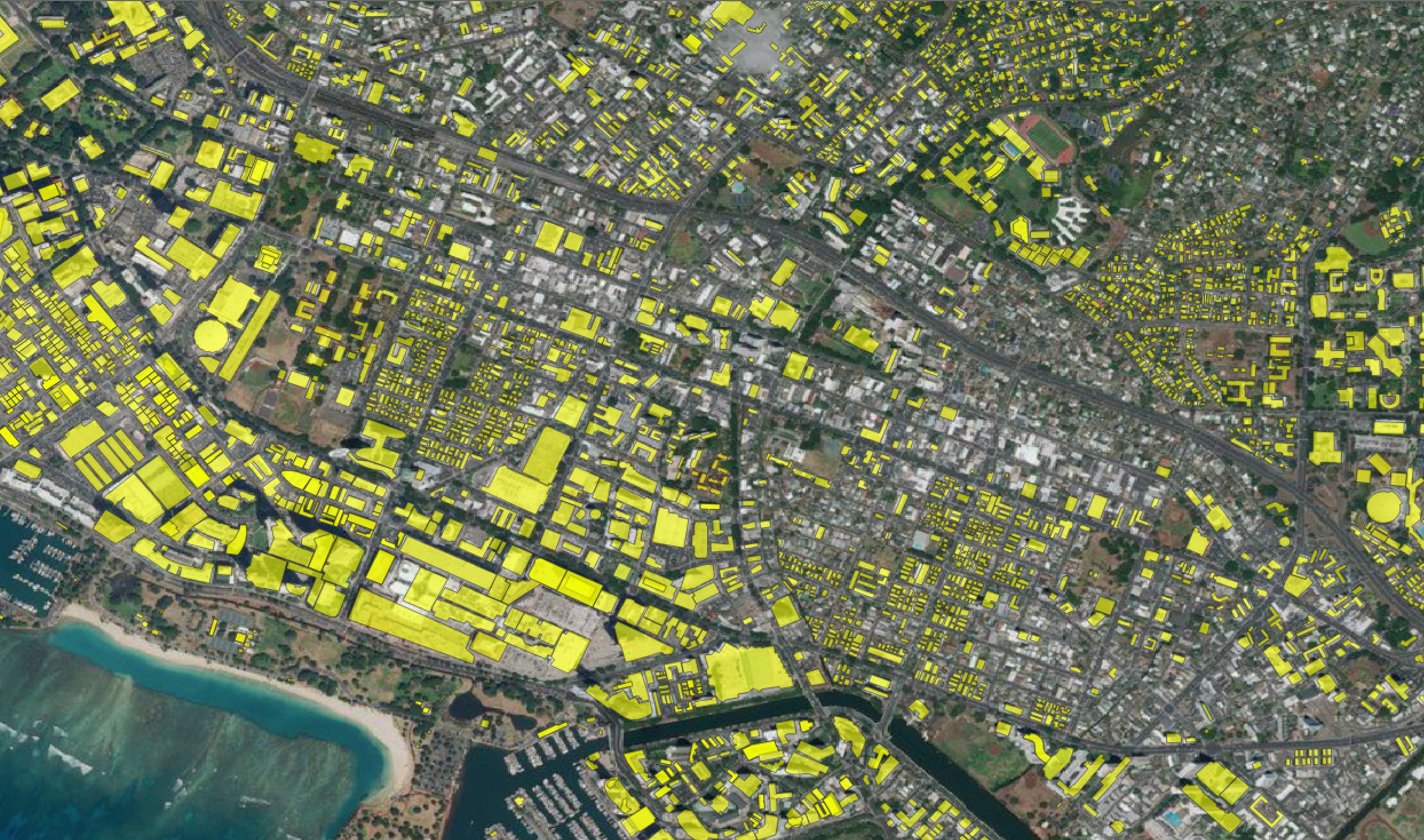
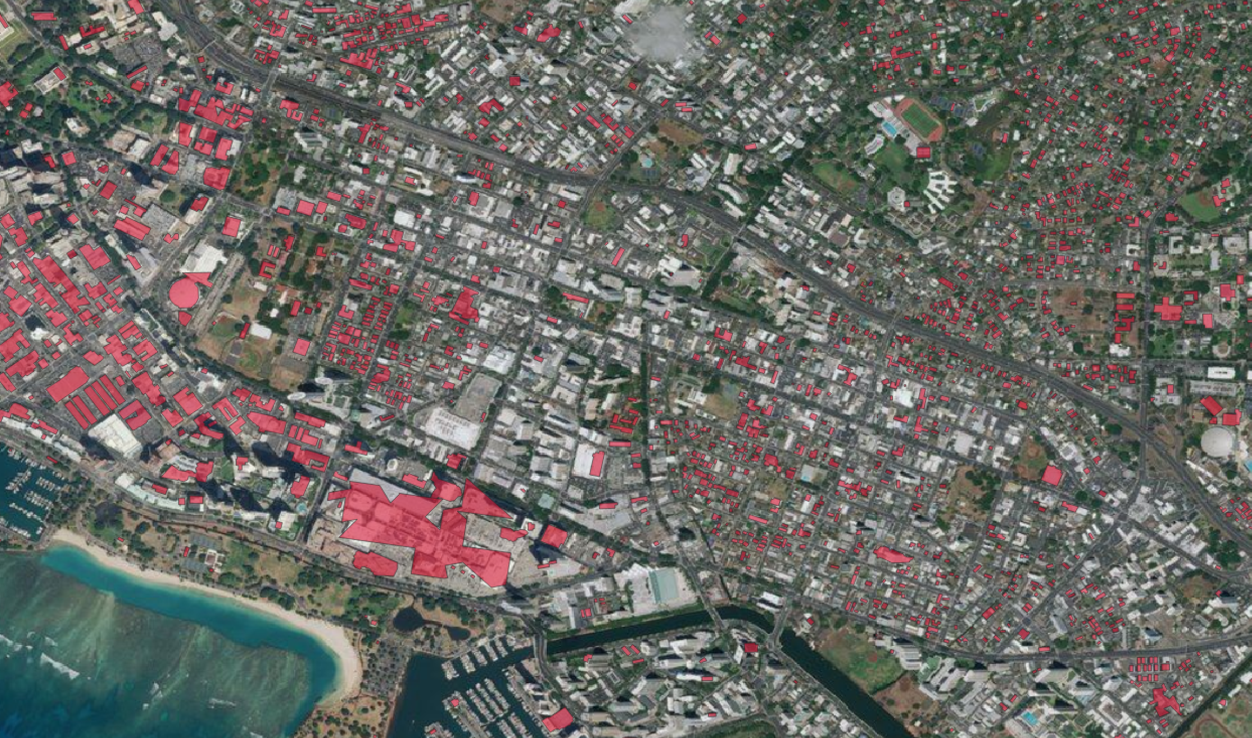
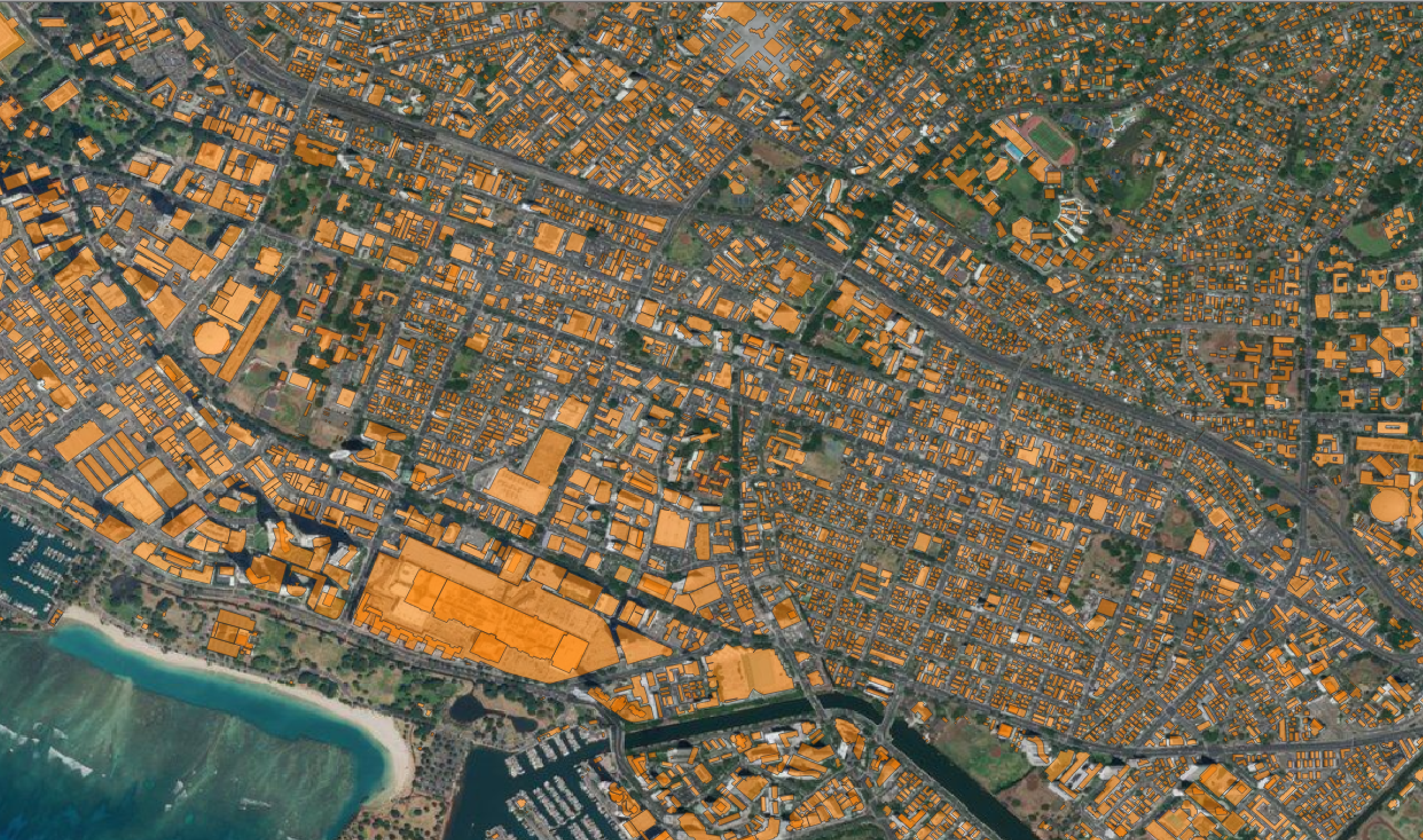
Comparison of OSM, Microsoft/Bing, and City & County of Honolulu’s Building Footprints

A quick comparison of OSM, Bing, and City & County of Honolulu building footprints suggests that the local source (CCH) is the most accurate of the three followed by OSM, and then Bing. Also note that the Bing building footprints (at least this version of the data update) does not have height information. OSM building extracts can either have height info or not depending on the file format and source - for example shapefiles from Geofabrik doesn’t have this info but *osm.pbf has more info. CCH’s building footprints has height info, although it is an older dataset, captured between 2004-2009.

OSM building footprints (yellow polygons) overlaid on Bing Aerial

OSM building footprints (yellow polygons) overlaid on Bing Aerial

Microsoft/Bing building footprints (red polygons) overlaid on Bing Aerial

Microsoft/Bing building footprints (red polygons) overlaid on Bing Aerial

City and County of Honolulu building footprints (orange polygons) overlaid on Bing Aerial

City and County of Honolulu building footprints (orange polygons) overlaid on Bing Aerial

I would say, always stick with your local source for building footprints but OSM and Bing building footprints will suffice for areas that don’t have data. Use whatever that will fit your purpose.

That’s all I have for now. Thanks for reading! :)